
Son My 1 Industrial Park (IPICO) - Lam Dong Province
- Investor: IPICO
- Price: 68 USD/M2
- Area: 1.070 Ha
Lam Dong Province, one of Vietnam’s five Central Highlands provinces, is the nation’s seventh-largest. It neighbors the key Southern economic area.
In 2018, Lam Dong was Vietnam’s 23rd most populous administrative unit. It ranked 23rd in Gross Regional Domestic Product (GRDP), 18th in per capita GRDP, and 26th in GRDP growth rate. The population was 1,312,900, with a GRDP of 78.433 trillion VND (3.4064 trillion USD), per capita GRDP of 59.74 million VND (2.595 USD), and GRDP growth rate of 8.14%.
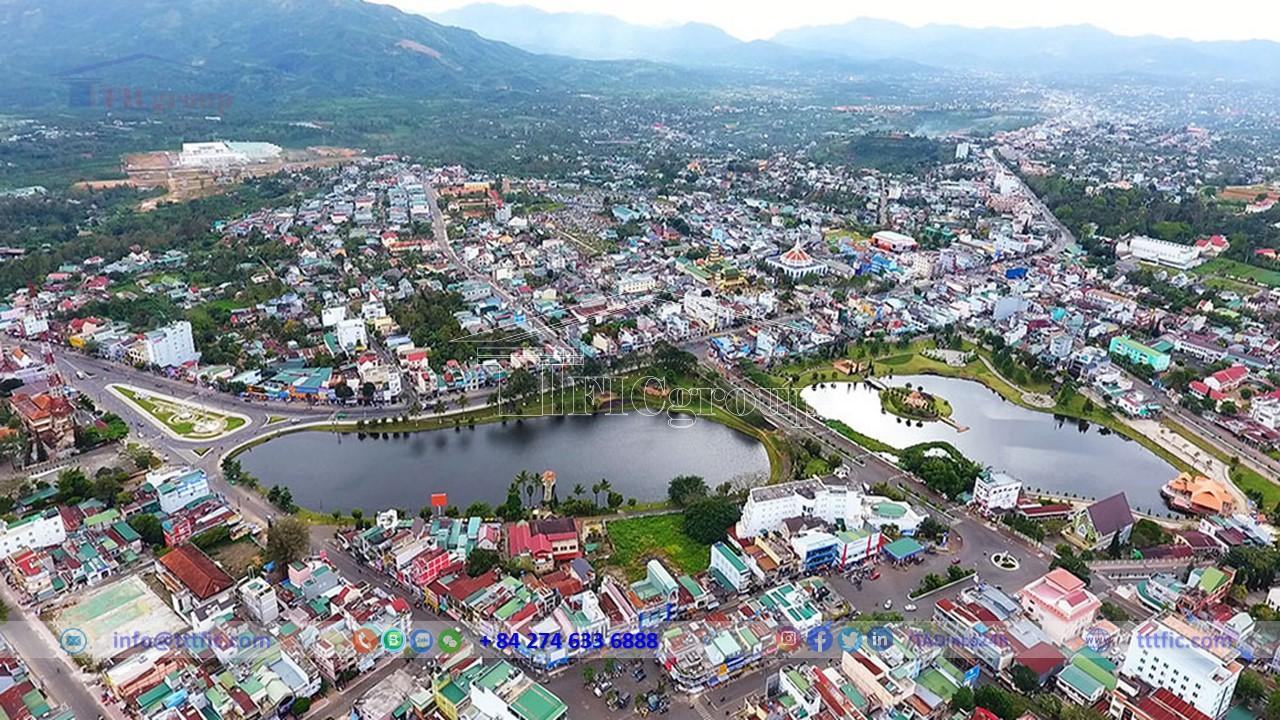
Lam Dong spans the three highest plateaus of the Central Highlands – Lam Vien, Di Linh, Bao Loc (formerly B’Lao) – at an elevation of 1500m above sea level. It’s the only Highlands province with no international border. Its capital, Da Lat, is 300km northeast of Ho Chi Minh City, 658km south of Da Nang, and 1,414km from Hanoi via Highway QL.1. In 2010, Lam Dong became the first Highlands province with two provincial cities (Da Lat, Bao Loc).
Lam Dong is located in Vietnam’s Southern Central Highlands. It sits between 11˚12’ – 12˚15’ North latitude and 107˚45’ East longitude. The province shares its borders with various neighboring provinces.
The area features remarkable mountain ranges. The northern Yang Bong peaks at 1749 meters, while the southern range includes several high peaks. Da Lat city, located on Lang Biang plateau, rests at 1475 meters above sea level.
Di Linh plateau in the east and south of the province has an elevation of 1010 meters. Bao Loc plateau in the southwest ranges from 900 to 1100 meters. Despite its location in the Central Highlands, Lam Dong has ties with the Southern region, notably in the military sector.
Covering 9,772.19 square kilometers, Lam Dong is a mountainous area in the Southern Central Highlands. Its average altitude varies between 800 and 1,000 meters. The landscape is diverse, offering a rich mix of climate, soil, flora, fauna, and stunning views.
The province is home to three plateaus and the origin of seven major rivers. It belongs to the crucial Southern economic region, known for its dynamism and high economic growth. Lam Dong focuses on several key industries, including long-term industrial crops, forestry, minerals, tourism-services, and livestock farming.
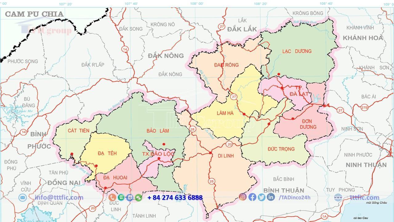
Located in Southern Central Highlands, Lam Dong is characterized by three plateaus (Lam Vien, Di Linh, Bao Loc) and major river systems. It mainly consists of mountains and plateaus averaging 800 to 1,000 meters above sea level, with some flat valleys.
Its geographical feature shows a clear gradient from north to south. The northern region is dominated by high mountains like Lang Bian and Bi Dup, ranging from 1,300m to 2,000m in height. East and west feature lower mountains (500-1,000m), while the south transitions from Di Linh – Bao Loc plateaus to semi-plateaus.
Lam Dong’s geological structure includes sedimentary, eruptive, and intrusive rocks dating from Middle Jurassic to Quaternary. There are 14 geological strata with different rock compositions and ages. The intrusive rocks belong to four complexes: Dinh Quan, Deo Ca, Ca Na, and Cu Mong.
The province lies southeast of the Da Lat zone, which is a Precambrian continental crust that subsided in the Early to Middle Jurassic. Most of this zone underwent vigorous magmatic activity in the Late Mesozoic and Cenozoic.
Lam Dong has an area of 977,219.6 ha of land, accounting for 98% of its natural area, including eight soil groups and 45 soil units:
– Alluvial soils (fluvisols)
– Gley soils (gleysols)
– Cambisols (cambisols)
– Black soils (luvisols)
– Red basalt soils (ferralsols)
– Gray soils (acrisols)
– Podzolic soils on high mountains (alisols)
– Strongly eroded soils (leptosols)
Land with a slope under 25o accounts for over 50%, while land with a slope above 25o accounts for nearly 50%. Lam Dong has high-quality, fertile soil. About 255,400 ha of land is suitable for agriculture, with 200,000 ha of basalt soil in Bao Loc – Di Linh perfect for cultivating valuable industrial crops like coffee, tea, and silkworm mulberry.
The area for tea and coffee cultivation is about 145,000 ha, mainly in Bao Lam, Bao Loc, Di Linh, and Lam Ha. Vegetable and flower cultivation covers about 23,800 ha, mainly in Da Lat, Don Duong, and Duc Trong. Agricultural land is diverse, with some high-value crops.
Despite its extensive size, the remaining agricultural land is widely dispersed and located far from residential areas, posing challenges for exploitation. These challenges include issues such as flooding, drought, shallow soil with exposed rocks, limited fertility, and low utilization rates. Within the forestry land area, forested land accounts for 60%, and the rest is bare hill (around 40%).
Influenced by the tropical monsoon climate varying with altitude, Lam Dong’s weather is divided into a rainy season from May to November and a dry season from December to April. Temperatures differ markedly between areas, with higher altitudes being cooler. The province’s average annual temperature ranges from 18 – 25°C, providing pleasant, cool weather all year round with minimal major fluctuations. Average annual rainfall varies between 1,750 – 3,150 mm, and the relative humidity averages 85 – 87% annually.
Da Lat, in Lam Dong, has a highland subtropical climate within the tropical savannah climate zone. It is close to urban centers and has abundant sunshine, making it ideal for resort tourism and temperate crops. Lam Dong benefits from a temperate climate near urban areas and populated plains.
Lam Dong, part of the Dong Nai river system, boasts a rich water source with a dense network of streams, harboring significant hydroelectric potential with 73 reservoirs and 92 dams. The rivers and streams are evenly distributed across Lam Dong, with most flowing from northeast to southwest. These waterways typically have small basins and many upstream cascades due to the hilly terrain.
The province’s major rivers belong to the Dong Nai river system, with Da Dang (Da Dong), La Nga, and Da Nhim being the three main rivers.
The water supply system is fairly well-established. It includes: the Da Lat water plant with a capacity of 35,000 m3/day-night, the Bao Loc town water system with a capacity of 10,000 m3/day-night, the Duc Trong district water system with a capacity of 2,500 m3/day-night, the Di Linh district water system with a capacity of 3,500 m3/day-night, and the Lam Ha district water system with a capacity of 6,000 m3/day-night. Alongside water supply, the wastewater treatment system for industrial and domestic use is also being enhanced.

The Covid-19 pandemic has slowed down economic growth in Lam Dong Province, affecting industries such as hospitality, dining, transport, and tourism. To revive the economy and combat the pandemic, Lam Dong implemented a temporary strategy of “safe adaptation, flexible control, and effective Covid-19 management.” This approach yielded positive socio-economic outcomes in 2021, ranking Lam Dong 44th in the national GRDP growth.
The economic structure of the year at current prices for sector I accounts for 41.09%, sector II accounts for 20.03%, and sector III accounts for 38.88%. The GRDP in 2021 is estimated to be 50,106.7 billion VND, up 2.58% over the same period; Sector I, including agriculture, forestry and fisheries, reached 18,996.2 billion VND, up 4.8% over 2020. Sector II, including industry and construction, reached 9,285.5 billion VND, up 6.28%. The service sector III reached 19,053.9 billion VND, down 1.84% compared to the same period. Product tax minus product subsidies reached 2,771.1 billion VND, up 7.71% over the same period.
The estimated total state budget revenue in the area reaches 10,749.6 billion VND, equaling 115.59% of the estimate and reflecting a 14.06% increase compared to the same period. The estimated total local budget expenditure amounts to 15,049.3 billion VND, accounting for 97.86% of the estimate and indicating a 2.2% increase over the same period.
Credit organizations in the area innovated credit mechanisms for agricultural and rural development, improving access to credit for farmers and businesses. Policies prioritize high-tech agriculture, facilitating access to preferential loans and supporting start-up projects. The estimated total mobilized capital of credit institutions in the area is projected to increase by 15.65% to reach 77,000 billion VND in 2021, compared to 2020. The total outstanding loans of credit institutions in the area reached 137,000 billion VND, up 18.52%.
In 2021, the total social investment capital in Lam Dong Province reached 27,868.2 billion VND, experiencing a 7.96% increase compared to the previous period. The state capital accounted for 30.52% of the total capital, reaching 6,806.7 billion VND and growing by 14.15%. Investment outside the state sector reached 20,913.9 billion VND, accounting for 69.06% of the total capital and experiencing a 7.37% increase. However, foreign direct investment decreased by 60.36%, reaching 147.6 billion VND and accounting for only 0.42% of the total capital.
The consumer price index (CPI) averaged 12 months in 2021 increased by 1.96% over the same period last year. Among the 11 groups of consumer goods and services, 9 groups experienced price index increases ranging from 0.17% to 7.48%. The medicine and medical services group increased by 0.17%, while the transport group had the highest increase of 7.48%. Culture, entertainment, and tourism decreased by 1.51%, and post and telecommunications decreased by 1.09%.
By December 31st, the province ensures social welfare and security in various aspects of life. An estimated 1,197,100 individuals are participating in health insurance and social insurance, with a health insurance coverage rate of 90.6%, indicating a 3.61% increase compared to the same period. By the end of 2021, the province expects a decrease in the poverty rate to 1.01%, while ethnic minorities are projected to have a poverty rate of 2.58% based on the multi-dimensional poverty standard from 2016 to 2020.. The number of unemployed individuals decreased from 32,047 in the third quarter of 2021 to 11,926 in the fourth quarter. The projected labor force by December 31, 2021, is 777,963 individuals.
As of April 1, 2019, the total population of Lam Dong Province reached 1,296,906, with a population density of 125 people/km². Urban population accounted for nearly 508,755, while rural population accounted for 788,151. The male population was 653,074, and the female population was 643,832. The natural population growth rate was 0.88 ‰. Lam Dong has the highest urbanization rate in the Central Highlands (42.7% as of 2022).
According to statistics from the General Statistics Office of Vietnam, as of April 1, 2009, there were 43 ethnic groups and 18 foreigners living in the province. The Kinh ethnic group was the largest with 901,316 people, followed by the Kaho with 145,665 people. The Mạ ranked third with 31,869 people, and the Nùng with 24,526 people. The Tày had 20,301 people, Chu Ru had 18,631 people, and the Hoa had 14,929 people. Other ethnic groups included the Mnông with 9,099 people, the Thái with 5,277 people, and the Mường with 4,445 people. The smallest ethnic groups were Lô Lô, Cơ Lao, and Cống, each with only one person.
Regarding religion, as of April 1, 2019, Lam Dong had 12 different religions, totaling 741,836 followers. The largest religious group was Catholic with 380,996 followers, followed by Buddhism with 200,560 followers. Protestantism had 113,536 followers, and Cao Dai had 46,220 followers. Other religions included Hoa Hao Buddhism with 330 followers, Islam with 75 followers, Baha’i with 72 followers, and 27 followers of Đạo Tứ Ân Hiếu Nghĩa. There were also 11 followers of Minh Sư Đạo, 5 followers of Bahá’í, 3 followers of Minh Lý Đạo, and 1 Vietnamese Buddhist monk.
As of September 30, 2011, Lam Dong Province had a total of 459 schools, including 37 high schools, 133 lower secondary schools, 251 primary schools, and 22 kindergartens. The education system in the province is relatively comprehensive, contributing to reducing illiteracy in the area.
The province is home to four universities: Dalat University, Yersin Dalat University, Ho Chi Minh City University of Architecture – Dalat Campus, and Ton Duc Thang University – Bao Loc Campus.
In 2011, Lam Dong Province had a total of 187 healthcare facilities under the Department of Health. These included 14 hospitals, 22 regional clinics, and 148 commune health stations. Additionally, there was one rehabilitation hospital with 3,015 beds. The healthcare staff consisted of 582 doctors, 596 nurses, 859 healthcare assistants, and approximately 483 midwives.


