Binh Dinh Province:
Binh Dinh province, a coastal province, nestles in the northern part of Vietnam’s South Central Coast region.
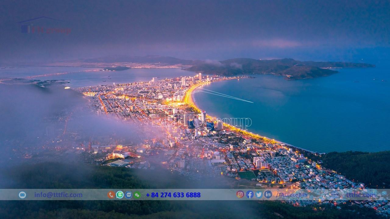
Its capital, the port city of Quy Nhon, is 1,070 km south of Hanoi, 323 km south of Da Nang, and 652 km north of Ho Chi Minh City via Highway 1.
In 2020, Binh Dinh ranked 20th in Vietnam in population, 15th in Gross Regional Domestic Product (GRDP), 20th in per capita GRDP, and 23rd in GRDP growth rate. The population stood at 2,526,752, with a GRDP of 219,409 billion dong ($7.42 billion), a per capita GRDP of 82,772 million dong ($3,510), and a GRDP growth rate of 7.32%.
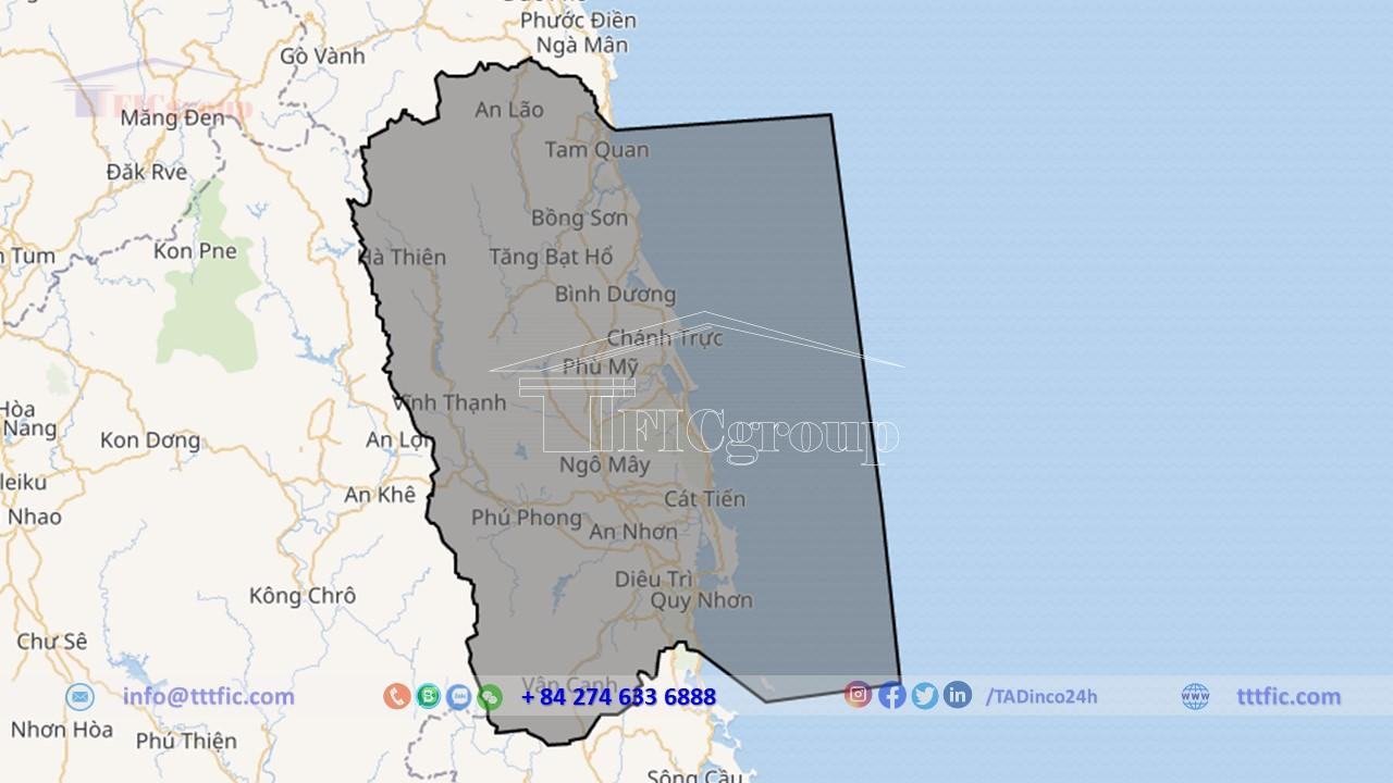
Located in the South Central Coast region of Vietnam, Binh Dinh has a total natural area of 6,025 km2. Binh Dinh province is bordered by Quang Ngai to the north, Phu Yen to the south, and Gia Lai to the west. The East Sea lies to the east. It is located 1,065 km from Hanoi, 686 km from Ho Chi Minh City, 300 km from Da Nang, and 300 km from the Bo Y international border gate (in Kon Tum province) through Laos. Binh Dinh is part of the Central Key Economic Region, along with Thua Thien Hue, Da Nang, Quang Nam, and Quang Ngai.
Geography of Binh Dinh Province:
Geographical location:
Located in Central Vietnam, Binh Dinh is a province that graces the coastline.. The province spans 110 km from north to south, with an average width of 55 km (narrowest at 50 km, widest at 60 km).
To the north, it shares a 63 km border with Quang Ngai (northernmost point coordinates: 14°42’10” N, 108°55’4” E). To the south, it borders Phu Yen with a 50 km shared boundary (southernmost point coordinates: 13°39’10” N, 108°54’00” E).
Its western edge is defined by a 130 km border with Gia Lai (westernmost point coordinates: 14°27′ N, 108°27′ E). To the east, it faces the East Sea, boasting a 134 km coastline; the easternmost point is Nhơn Châu (Cù Lao Xanh) in Quy Nhon city (coordinates: 13°36’33 N, 109°21′ E).
Binh Dinh is considered a gateway to the sea for provinces in the Western Highlands and southern Laos.
Topography:
Binh Dinh’s topography, complex and diverse, descends from west to east. The western province holds the eastern edge of the Southern Truong Son Range, succeeded by the midlands and coastal areas.
Mountainous regions lie in the northwest and west. Occupying about 249,866 ha, these slopes are mainly distributed in An Lao, Vinh Thanh, Van Canh, Tay Son, and Hoai An. The average elevation ranges between 500-1,000 m, with eleven peaks surpassing 1,000 m. Coastal geology is characterized by alternating low mountain ranges, sand dunes, and lagoons.
The hill zone bridges the western mountains with the eastern plains. This area covers approximately 159,276 ha, with an altitude under 100 m and slopes ranging from 10° to 15°. Townships like Hoai Nhon, An Lao, and Van Canh mainly feature this terrain.
The plains are not typical alluvial plains. They are mostly smaller plains, divided by lagoons, sand dunes, or mountain ranges. These plains usually lie along rivers or near the sea and have an average elevation of 25-50 m, covering about 1,000 km². The largest plain is at the lower part of the Con River.
Coastal areas include sand dunes and sand hills, forming a narrow strip along the coast. The scale and shape of this terrain fluctuate over time. There are large sand strips from Ha Ra to Tan Phung, Tan Phung to Vinh Loi, De Gi to Tan Thang, Trung Luong to Ly Hung. There are also many lagoons and bays, and several beach gates for water exchange between the river and the sea.
Island:
Binh Dinh’s coastline features 33 islands, grouped into 10 clusters or standalone islands.
Quy Nhon city’s sea area includes prominent clusters like Cu Lao Xanh, Hon Dat, Hon Kho, Nghiem Kinh Chieu, and Hon Can. Among these, Cu Lao Xanh is inhabited, while others mainly consist of rocks and sand.
Phu My district’s sea area features the Hon Trau cluster, Hon Kho or Hon Rua, and three smaller islands near My Tho commune: Hon Dun, Hon Tranh, and Hon Nhan.
Along the coastline, besides the guiding lights for ships entering and exiting Quy Nhon port, Binh Dinh has two lighthouses. One is located on the northern slope of Go Dua mountain, known as Vung Moi or Hon Nuoc Lighthouse. The second one is on Cu Lao Xanh island.
River:
Rivers in Binh Dinh originate from highlands of the eastern Truong Son range. These rivers are short, steep, low in silt, with total water reserves of 5.2 billion m³ and hydropower potential of 182.4 million kW.
Rivers with steep gradients in the upper areas contribute to rapid flood rise and fall. In the lower plains, riverbeds are wide, shallow, and riddled with streams, often facing water scarcity but also prone to extended flooding.
Prominent rivers include the Con, Lai Giang, La Tinh, Ha Thanh, and smaller ones like Chau Truc or Tam Quan. Numerous small streams and a network of mountain rivers are beneficial for irrigation and hydropower development.
Forest coverage has reduced to just over 40%, leading to annual floods, sedimentation, and severe water erosion. Conversely, rivers often run dry during the dry season, resulting in water scarcity for irrigation.

Lake lagoon:
Binh Dinh Province hosts numerous artificial lakes for irrigation during the dry season. Notable ones include Hung Long (An Lao), Van Hoi, My Duc, Thach Khe (Hoai An), My Binh (Hoai Nhon), Hoi Son, My Thuan (Phu Cat), Diem Tieu, Hoc Nhan, Phu Ha (Phu My), Dinh Binh, Thuan Ninh (Tay Son), Nui Mot (Van Canh – An Nhon), Vinh Son, Dinh Binh (Vinh Thanh).
Binh Dinh also possesses Tra O, a sizable freshwater reservoir (Phu My), and two brackish lagoons: De Gi (Phu My – Phu Cat) and Thi Nai (Tuy Phuoc – Quy Nhon). These reservoirs facilitate agricultural development and aquaculture.
In particular, the large Thi Nai lagoon supports the development of a national-level seaport and contributes to the economic growth of the Nhon Hoi region. Known for hosting Vietnam’s second longest sea-crossing bridge after Dinh Vu (Hai Phong), the lagoon is a noteworthy feature.
Climate:
Binh Dinh’s climate is characterized by tropical humidity and monsoons, which often change direction and intensity due to complex terrain.
Average annual temperatures range from 20.1 – 26.1 °C in the mountainous region, peaking at 31.7 °C and dropping to 16.5 °C. Coastal areas experience an average temperature of 27.0 °C, with highs of 39.9 °C and lows of 15.8 °C.
Relative humidity is between 79-92% in the mountainous region and 79% in coastal areas, with average absolute humidity values of 22.5 – 27.9% and 27.9% respectively.
The rainy season stretches from September to December, with an additional rainy period from May to August in the mountains, due to the influence of the Western Highlands’ monsoon. The dry season spans from January to August.
Average annual rainfall ranges from 2,000 – 2,400 mm in mountainous districts and 1,751 mm in coastal areas, gradually decreasing from the mountains to the coast and from northwest to southeast.
Regarding typhoons, Binh Dinh lies in the South Central Coastal region, a common area for landfall. On average, 1.04 typhoons hit the coastline from Quang Nam – Da Nang to Khanh Hoa each year, most frequently between September and November.
Economy of Binh Dinh Province:
Binh Dinh has a key economic position, centrally located in Vietnam’s North-South railway and road system. It acts as a crucial gateway to the East Sea for the Central Highlands, Southern Laos, Northeast Cambodia, and Northeast Thailand via National Highway 19 and Quy Nhon international seaport. Binh Dinh boasts abundant natural resources, a rich cultural heritage, and a plentiful workforce. Binh Dinh strives to become a province with advanced industry and a major hub for socio-economic progress. It aims to contribute to the development of the Central Key Economic Region and the entire nation, enhancing people’s livelihoods, preserving the ecological environment, and ensuring security and defense.
In 2018:
In 2018, Binh Dinh province achieved strong economic growth, surpassing targets in various sectors. The Gross Regional Domestic Product (GRDP) increased by 7.32%, exceeding the target of 7-7.2%. The agriculture, forestry, and fisheries sector grew by 4.99%, surpassing the target of 3%. The industrial and construction sector saw a growth of 9.03%, meeting the target of 10-10.2%. The service sector also performed well, with a growth rate of 7.38%, meeting the target of 7.2-7.5%.
The industrial production index rose by 8.71%, slightly below the target of 9%. The total export turnover reached $800 million, meeting the target. Social investment capital increased by 9.7%, exceeding the target of 9.22%. The total budget revenue reached VND 8,466.4 billion, surpassing the estimated figure by 25%. Forest coverage reached 54%, exceeding the target of 53%.
In terms of social indicators, positive progress was made. The birth rate decreased by 0.1‰, exceeding the target. The province created new jobs for 29,917 workers, surpassing the target. The rate of trained and skilled labor reached 52%, exceeding the target. The poverty rate dropped to 7.05%, surpassing the target based on new criteria. The health insurance coverage rate reached 89.7%, exceeding the target. Healthcare stations with doctors met the target of 100%, and the rate of communes meeting national health standards was 97.5%. The availability of hospital beds per 10,000 people exceeded the target. Additionally, the rate of malnourished children under 5 years old was below the target.
Regarding environmental indicators, progress was made in improving access to clean water and sanitation. 79% of urban populations had access to clean water, meeting the target. 98% of rural populations had access to clean water and adequate sanitation, meeting the target. The solid waste collection rate in urban areas reached 85%, surpassing the target of 80%.
In 2019
In 2019, the economic growth rate was 6.81%, lower than the previous year. The total budget revenue for the year reached over VND 12 trillion, a nearly 34% increase compared to 2018, exceeding the estimated figure by 20.7%. The total investment capital for development on the province’s territory reached VND
35.377 trillion, a 17% increase compared to 2018. State budget investment capital amounted to VND 6.286 trillion, a 76.4% increase compared to the same period.
In 2019, the total aquaculture output on the province’s territory exceeded 257,000 tons, a 5.6% increase compared to 2018. Tuna production reached 11,300 tons, a 6.3% increase.
Residential:
Binh Dinh has a natural area of 6,022.6 km² and a population of 1,487,009 people (as of 2021). The population density is 389 people/km² (data from World Population Review, August 2021).
According to the latest population census in August 2021, the province has a total population of 1,487,009, with males accounting for 49.2% and females accounting for 50.8%. The urban population represents 31.9%, while the rural population represents 68.1%. The population density is 246 people/km², and the working-age population makes up approximately 58.8% of the total population. In addition to the majority Kinh ethnic group, there are other ethnic groups in the province, including Chăm, Ba Na, and Hrê, with a population of around 25,000.
The distribution of the population across the province is uneven, with a population density of 251.8 people/km². The highest population concentration is in Quy Nhon city (with an average population density of 1,007.2 people/km²), followed by An Nhon town (with an average density of 752.8 people/km²) and Hoai Nhon town (with an average density of 502.2 people/km²). The lowest population density is in Van Canh district with 31.6 people/km². The urbanization rate is projected to reach 46.3% by 2023.
As of April 1, 2019, Binh Dinh province had a population adhering to nine different religions, totaling 124,348 people. The largest religious group is Catholicism with 36,299 followers, followed by Buddhism with 23,460 followers. Other religions include Caodaism with 13,118 followers, Protestantism with 1,321 followers. There are also smaller populations practicing Hoa Hao Buddhism (94 people), Baha’i Faith (26 people), Islam (19 people), Bà La Môn religion (10 people), and Minh Ly Dao (1 person).